Saturday, July 31, 2010

Introduction to the Chilkoot Trail

There were a host of reasons Nola and I wanted to visit Alaska this summer of 2010. For me they not only involved the opportunities to fish, kayak, hike, and explore, but to learn more about the colorful history of Alaska. By hiking the Chilkoot Trail, we could retrace the journey of the 1898 prospectors firsthand. Another big one, however, involved investigating the history of my grandfather who ran off to Alaska from Waterville, Maine sometime in the late 1920s. He left his family of five young sons and a wife behind to fend for themselves during the Great Depression and eventually returned many years later in a pine box.  I assumed that he ran off to make a fortune in the goldfields, but by then the gold had played out and it turns out that he worked on the railroad somewhere between Anchorage and Fairbanks according to family history. I found that the railroads were just as important as gold in establishing the early fortunes of Alaska. Indeed, the city of Dyea died out rather quickly in the early 1900s when Skagway was chosen as the main starting point for the railroad to Whitehorse and beyond.

The Beginning of the Chilkoot Trail at Dyea Campground

In the days of the actual gold rush, prospectors were normally ferried from Skagway to Dyea where they would start preparations for hiking the Chilkoot Trail to eventually reach the goldfields around Dawson City some 600 miles away. This was the most popular access route from the coast to the Yukon goldfields, the shortest and least expensive.  In 1898, Dyea had 150 businesses, 48 hotels, and 2 hospitals. By 1903, all were abandoned leaving just three people as the resident population. Today, the combination of this historic American and Canadian route is celebrated and preserved as part of the Klondike Gold Rush National Historic Park (USA) and Chilkoot Trail National Historic Site (of Canada). For the early prospectors, it was necessary to haul one ton (2000 pounds) of gear over the Pass to the Canadian side which included such things as 150 pounds of bacon, 400 pounds of flour, 125 pounds of beans, 75 pounds of dried fruits, and other assorted foodstuffs including coffee, tea, sugar, etc. In short, enough provisions to last one full year.

Nola on the way up Saintly Hill in the first mile of the Chilkoot Trail


For us? Well...forget the one ton of goods. We decided to bring our day packs, take a lunch, pack our rain gear, wear bear bells, and make an exploratory trip of one day to Finnegan's Point, about 7 miles round trip from our campsite. We wanted to test it out to see if we were really interested in completing the entire hike of 33 miles to Bennett Lake in B.C. at a later date. But it became apparent after completing the first leg of the journey up Saintly Hill that Nola's ankles and feet would not survive the whole trek without a lot of pain. In my case, I was surprised at my huffing and puffing at the beginning, but felt a lot better by time we reached the top. I attributed my own slow pace to being out of shape from too much driving instead of biking or hiking up demanding hills and mountains. So, this hill was just enough challenge to start the trip off. It felt great when we reached the top and a relief to find out that the trail was not all straight up for the entire day. Saintly Hill deserves its name from the fact that anyone is a saint if they do not curse on their way up. Despite the initial challenge, I ended up loving the trip and I found out quickly that I am no saint.

 Love those well built bridges that make the trail flat, dry and scenic.

Zen views of Face Mountain 

The initial hills gave way to well worn trails that often bordered the Taiya River offering a variety of zen views. We eventually walked across swampland aided by parallel walking boards. That made it easy and exciting at the same time looking for beaver, muskrats, and birdlife along the way. Can't imagine what the trail looked like in 1898.

Crossing the swampland looking for beaver, muskrats and birdlife.

Eventually we penetrated a dark, brooding forest with zillions of mosquitoes droning around our heads...among our first in Alaska. As long as we kept walking it wasn't so bad, but we rested a few minutes for a quick lunch and they attacked us like the Mongol warriors of Genghis Khan. That was the quickest lunch ever as we had forgotten our head nets thinking we had somehow escaped mosquito season. Big mistake!

The dark forest beckons the unwary hiker.

It was tough for me to turn around at only 3.3 miles and retrace our steps. I really wanted to see what was up ahead and go through the more challenging parts of the trail experiencing Canyon City, Pleasant Camp, Sheep Camp, The Scales, The Golden Stairs, the Chilkoot Pass, and the trails to Lindeman and Bennett Lakes. So I decided to do it later in the summer by myself and join another 50 or so hikers who would sign the register, pay $50 in fees, and join the tens of thousands of others who have made this trek in the past. This appeared to be a challenging hike offering a variety of scenery with remnants of items along the trail left by earlier hikers and prospectors, and a good feeling for what it must have been like during those earlier days.  Of course, the first day was the easy part.  But...it looks like a great adventure!

 A documentary in the making with Canadian actor volunteers and Canadian Public Television of Quebec.


As we made our way back along the path, we started meeting more day trekkers. Most were part of small tour groups offered by Princess Cruise Lines who practically owned the nearby port of Skagway. But the biggest surprise was to meet a television production crew and volunteer actors from Canadian Television making a film for Public Television in Quebec. With a group of about 20 people selected from all over Canada, they were involved in the reenactment and filming of the early French voyagers and prospectors who had climbed the Chilkoot Trail and went on to Dawson City.  Dressed in typical dress of the time, using similar tools, camping and cooking like those of 1898, the film would document what it was like for today's adventurers to spend three months slowly making their way with all of their struggles and  triumphs to Dawson City. With any luck, we would meet them once again on their entrance to Dawson City in August.

        One of the Canadian actors with blisters becomes the cook.

Two actors had blisters from the old style boots used on the trek and spent their days in camp as cooks and camp helpers. Note the use of flip flops for the day as their feet healed.  The documentary required that all actors wear clothing of the time for the entire length of the film (three months), and eat similar food from their 500 pounds of gear they were required to transport for this journey (rather than the full 2000 pounds per person for a year).

Home Sweet Home on the Chilkoot Trail


Thursday, July 22, 2010

Part II. Whitehorse to Skagway, Alaska

We spent our last night in Whitehorse at the local Walmart where we free camped with 35 other RV rigs.  It was a bit like an RV rally of people driving to Alaska and points north. Met one traveler who was developing a bear alarm for tent campers to warn them if a bear was too close while they were sleeping.  A fairly simple device with a nylon line rigged around the tent so that a pocket sized alarm went off if something disturbed it.  He showed me the prototype and it looked good to me. For the previous five nights we have stayed at the Hi Country RV Park which provided a rest bit and a chance to catch up on the internet, collect mail, take a long shower, do laundry, and explore Whitehorse on foot. But now we are set to embark on Part II of our adventure...driving to and experiencing the real Alaska!


The road to Skagway from Whitehorse is called the South Klondike Highway and is the most scenic route into interior Alaska (or so I was told). It's another journey into the beauty of the natural world with snow capped mountains, emerald lakes and glacial rivers presenting one spectacular view after another.  Only 110 miles in length, this is a great side trip off the Alaska Highway either continuing by ferry to Haines and other southeast Alaska points or returning back to Whitehorse to continue on to Tok, Alaska. 


Yahoo! Our first entry to Alaska was near the outpost of Fraser, British Columbia.  The border crossing was easy with one lone patrolman asking us a few casual questions about where we had traveled and future destinations in a cheery manner. This was in contrast to the Canadian border patrol who have been stern, uptight, and all business on our previous crossings into Canada. I commented to my wife..."What's their problem?" On the other hand, I wonder how the American border patrol treats the Canadians. On this trip I have heard horror stories about Europeans entering the USA by air and grilled up to 30 minutes, not once but several times as they move from one area of the airport to another. As a result, I have met several German and Swiss travelers in B.C. who told me they refuse to travel to the USA now and confine their North American travel to Canada. The last time I traveled from Istanbul, Turkey to New York, I was questioned four times with accompanying baggage search before I was allowed to enter the airplane. I asked the Turkish authorities about the redundant searches and one officer replied that it was demanded by the American authorities. It's a sad time for world travel and the air industry as compared to the hey days of Pan Am and TWA when air travel was great fun.  After more than 50 years of flying around the world many times on business and pleasure, I rarely travel by plane anymore and much prefer to drive our motorhome or tour by recumbent bicycle. 


One of my goals on this trip was to experience the days of the Klondike and get a feeling for what it must have been like to search for gold in the frenzy of the Gold Rush of 1898. No better place to begin this side adventure than camping at Dyea Campground and possibly hiking the Chilkoot Trail over White Mountain Pass and relive the stories and days of yesteryear. We entered Dyea Junction in the late afternoon of June 8th about ten miles prior to reaching Skagway; left the tarmac and traveled eight miles on a twisting, gravel road to the former town of Dyea.  We were at the starting point of the Chilkoot Trail and the former site of a city that contained a population of over 10,000 people in 1898 that rivaled Skagway in size at the time.  Now a National Historical Park, all that's left are remnants of a wharf that received supplies and gold seekers traveling up the inland passage, a few scattered buildings, a cemetery, and a campground for present day visitors. 


We were very fortunate to meet the campground volunteers, Judy and Jim Finses of California, who took us on a personal tour of Dyea and learned that there were over 40 graves in the Slide Cemetery many bearing the date of the Palm Sunday avalanche. After viewing the waterfront remains, the Taiya River where pink salmon swim upstream in July pursued by brown and grizzly bears, and the remains of Slide Cemetery, we were ready to hit the sack and dream about the Gold Rush of 1898.  Jim left us with one admonition, "Beware of the grizzly bears in camp!"


Friday, July 16, 2010

McBride Museum of Yukon History

I'm not especially a great fan of museums.  I'd rather be out doing something like creating a new adventure. But I really liked the McBride Museum. This North Country is so vast that I found a look at the past is helpful to understanding the phenomenon of the 1897 Gold Rush and how it relates to the present day Yukon Territory.


This is a history laden series of buildings that offer displays, interpretive programs, guided tours, geology, natural history, programs on the NW Mounted Police (Mounties), and exhibits of the native peoples, and the Gold Rush.


This was a great opportunity to review the natural history and animal life of this region. So far we had seen many of the animals preserved in the museum, except for the elusive wolverine. Along the highway, on our walks, or on the lakes, we had seen bear (grizzly and black), moose, snowshoe hare, beavers, muskrats, wolves, and Mountain Sheep. We were still looking for Caribou and Wolverines.


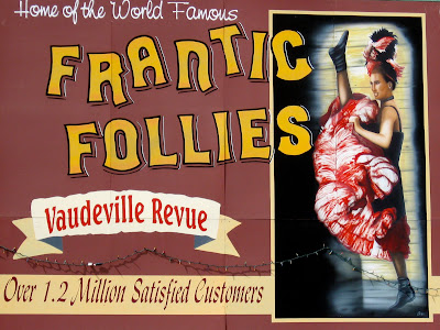
The museum also provides an unusual glimpse of life in the late 1800s. From Sam McGee's cabin to the everyday life of the prospector, a visit provides an opportunity to delve deeper into the era of the Gold Rush. As I said previously, one can get a great overview of the Yukon Territory and the city of Whitehorse by walking around the city on the many walking paths in and out of Whitehorse, visiting the McBride Museum during the day, and visiting the Frantic Follies at night.  This is a great town!

Whitehorse, Yesterday and Today

I like Whitehorse! First of all this is a great walking and bicycling town with about 25,000 residents, most of them attractive, young and healthy. Canoes, kayaks, and bicycles adorn every other car. What a great outdoor center!  Reminds me very much of Bend, Oregon where we spend many of our summers these days.  Mountains in the background, a river flowing through the middle of town, lively coffee and bakery spots, and beautiful women and handsome young men.  And lots of historic and natural history museums.  A great mix of the past with a dynamic present and an unlimited future.


Whitehorse derived its present name from the White Horse Rapids which looked like "the flowing manes of charging white horses".  These rapids, located south of the city in the dangerous Miles Canyon, offered a series of water hazards and obstacles that challenged the best of the early river runners. Initially tramways were built to deliver goods around the rapids in 1897, then the railway bypassed the rapids in 1900 to connect rail service and riverboats to Dawson City.  Now the Yukon river has been tamed by the Whitehorse hydro-electric dam and the capital of the Yukon Territory was moved from Dawson City to Whitehorse. The city has experienced a series of boom and bust times over the years including the last one which was fueled by the construction of the Alaska-Canada Highway. Owing much of its wealth to the mining industry, tourism also plays an important role today in the building of this dynamic young community.


The sternwheeler, S.S. Klondike, serves as a reminder of the importance Whitehorse played as a major transportation center of this region as well as a starting point for miners and prospectors seeking their fortunes in the gold fields.  In its heyday, there were over 250 riverboats plying the Yukon River, making Whitehorse an important riverboat port rivaling those on the Mississippi. However, when the gold boom was over, the population dropped to about 300 residents. It wasn't until 1942 and the construction of the Alaska Highway that Whitehorse regained its economic clout and political domination of the Yukon Territory.


This is the first town on our trip where I just liked hanging out and watching the people go by while sipping coffee and sampling the local pastry delights. It's small enough that it has a distinct personality that is inviting. I suppose that I sound like the local Chamber of Commerce but I think we build the majority of our cities in the Lower 48 too big, too sprawling, and too impersonal. So when I experience a smaller town like this, I like to acknowledge the city planners and residents that something is going right. If it didn't have temps in the minus fifties during the winter, I'd be tempted to move. Well...maybe. Well...OK...I'm getting a bit carried away for I love Bend and Eugene, Oregon.


This is a modern, thriving town that blends the old and new with wide streets, interesting shops, coffee houses, art galleries, inviting restaurants, outdoor outfitters, grocery stores, government buildings, tourism offices, and a variety of museums, parks, and healthy, friendly people plus plenty of RV parks not too far from downtown.


One can visit the White Pass Railroad Station Depot as well as a number of other historical buildings.


Geez!  It didn't take long for my wife Nola to be swept away by the North West Mounted Moose guarding the streets of downtown Whitehorse. Gotta watch her every minute!


I especially liked the murals that reminded me of the gold rush in the Klondike and the many challenges prospectors faced to reach Dawson City by way of the Chilkoot Trail.      


But I was most taken with the thoughts of what life must have been like in those frantic times when all was sacrificed to reach the gold fields. Nothing bought the whole era together better for me than a day at the McBride Museum and an evening at the Frantic Follies.  


The Frantic Follies initially appeared in 1981 and has been a success ever since.  A creation of Jim Murdoch, it has captured the hearts of the Yukon as well as my own. I enjoyed it immensely and recommend it as part of any visit to Whitehorse.


Tuesday, July 13, 2010

Whitehorse, Yukon Territory and Travel Logistics


Yahoo! Reaching Whitehorse in the Yukon Territory was the first goal on our trip to Alaska. From here we will leave the Alaska - Canada Highway and take the Klondike Highway to enter Alaska and the historic town of Skagway. Whitehorse serves as a pivot point, economic hub, capital and largest city of the Yukon Territory. For us and most other Alaska bound travelers, it is a place to relax, delve into the history of the gold rush era, and participate in a variety of attractions and outdoor adventures offered by local tour operators. With a Walmart and several large grocery stores, we wanted to stock up on groceries and supplies, make any needed repairs, and get ready for the next leg. We plan to return here at a later date in August or early September after taking the Top-of-the-World Highway to Dawson City on our trip back to the USA. The map below, compliments of www. geology.com, shows the geographic position of Whitehorse to Alaska, BC, and the Northwest Territories. With the exception of the last six miles of the Cassiar Highway, the main roads were excellent, far exceeding my expectations.


It has taken a very leisurely 13 days to reach this point enjoying the incredible scenery, lakes, road system, people, wildlife, and parks of British Columbia.  By crossing the Canadian border on May 20, we enjoyed sunny, warmish weather as we left the rains and overcast days of Oregon behind us.  At first, we debated whether to leave at such an early date, but as I had learned on previous trips, the best weather in Alaska is usually in May and June.  In a summary of costs thus far, we spent a total of $1225 or approximately $94 per day. This broke down to $246 for campsites (averaging $19 a night), $184 for groceries and dining out (average of $14 a day), approximately $720 for gas ($55 a day), $75 for other items including museum entrance fees, and a 10-day fishing license in BC for $52 (average of $6 a day). We used about 180 gallons of gas at an average of $4.00 a gallon for 1600 miles yielding 9 miles to the gallon.  Gas was the major cost item simply because we needed to cover a large distance. Anyone who has not driven a motorhome may be shocked by nine miles to the gallon, but most 27 foot RVs with gas engines will average about 8-10 miles to the gallon.  With kayaks on top, our efficiency drops a bit although we balance this out by driving about 50 mph rather than our normal 55. Once we reach our main destinations like Homer, Alaska, we can relax and spend a week or more in most camp sites to reduce overall expenses.  Our budget is $2500 a month.

Friday, July 9, 2010

Carcross and Caribou Crossing

Looking at the map on our way to Whitehorse, Yukon Territory, I saw that we were close to the towns of Tagish and Carcross.  It wasn't until we were actually in Carcross that I made the connection between the Tlingit people of Carcross and the Athabascan community of Tagish. If I had followed a cultural itinerary, we would have traveled to these aboriginal communities first before entering the capital city of the Yukon.  So in this blog that is exactly what I am doing to make more sense of this cultural milieu.


The Tlingit people called this area Naataase Heen, "water running through the narrows."  The Tagish called it Todezzane, "blowing all the time." In 1898, it served as a North-West Mounted Police post and a First Nation community. By 1899, they called this community Caribou Crossing, where the local woodland caribou crossed the narrows of Carcross River as it emptied into Bennett Lake. By 1900, a rail line was constructed to Atlin.  By 1902, the Post Office and Telegraph Office shared space in the same building with the NWM Police. In 1906, it was officially named simply Carcross.  By 1909, much of town burned down only to start all over again.


There was something intriguing about the remnants of this town as I walked from building to building trying to figure out what it must have been like during the days of the Klondike gold rush and the prospector's determination for getting to Dawson City. It had the feeling of early homemade frontier architecture melding into the present day.  In fact, many of the originals survived to this day where property values have gone through the roof, so to speak.  What looked like a shack to be purchased for $20,000 was worth more than $200,000 with a stunning view of the lake.


This is the Bobby Watson House which was originally built in 1903. In the 1920's, it housed the local Mounties and a jail.  In 1955, it became a residence once again for the son of Matthew Watson who purchased it in 1914.


In the 1940s as other towns failed and were abandoned, notable buildings were brought to Carcross.  Among them was St. John the Baptist Catholic Church which holds services today on every Sunday.


In a more typical log cabin design, new homes are starting to be built in this area of booms and busts, heartbreaks and euphoria, subsistence and accumulation, harmony with nature and living on the grid.  All grist for the mill!

Tlingit Country, Totem Poles, and Change

I first encountered the Tlingit Indians in Sitka, Alaska on a stopover using the Alaska State Ferry system over 20 years ago.  I was fascinated by their totem poles, meeting houses, sea going canoes, and elaborate carvings made of cedar. However, it was a surprise to learn there were Tlingit tribal members also living in interior Alaska and the Yukon.  I had assumed that the Haida and Tlingit lived primarily in Southeastern Alaska and British Columbia and the Athabascan dominated the interior but here were the Tlingit living on Teslin Lake, a huge body of water some 86 miles long with Lake trout, Grayling, and Dolly Varden.


I've always been fascinated by Totem Poles. The Teslin Tlingit Heritage Center answered one of my life long questions, "What do they symbolize?" I learned that they represent the tribes and elements of their society: the eagle (air), frog (water), wolf (land), beaver (water), and raven (air). The Heritage Center explains this as well as a good deal more about the culture of the Inland Tlingit with about 450 members living in Teslin. "Their own name for themselves is Lingit, meaning human beings." Whatever their past language grouping, I found that most of the First Nation People I met in Canada spoke excellent English. And I was fascinated by the fact the Tlingit are a matrimonial society that developed a hunter-gatherer culture primarily based on the salmon along the coast and hunting, fishing, and trapping in the interior.


Despite the devastation of these inland peoples caused by the building of the Alaska Highway in 1942, the story and success of George Johnston is noteworthy.  He was a revered Tlingit Elder (1884 -1982), skillful trapper, successful fur trader, an accomplished entrepreneur, and a dynamic photographer. But of all the stories I heard at the museum, I loved the tales most about his beloved 1928 Chevrolet.  It seems no matter the age, the hardships, or the society, there is always one person who stands out. In hindsight, I wish we had stayed longer in Teslin but the Call of the Yukon beckoned us forward.

Thursday, July 8, 2010

Entering the Yukon Territory

On July 1st we slowly made our way on a difficult six mile stretch of gravel road that would complete all 450 miles of the Cassiar Highway. Traffic slowed to ten miles an hour as we approached the famed Alaska Highway (ALCAN). It made me wonder...how many more miles of gravel and rough roads will there be on our way to and through Alaska? If we had a breakdown, would our insurance and emergency road services such as Coach-Net or Good Sam be able to help us?  I knew we had it easy today as stories about the early road travelers to Alaska and the Yukon are legendary, with tires, front ends, radiators, fenders and entire cars or trucks littering the sides of the highway. We had it very easy so far: a great road, great campgrounds, great weather, great fishing...and few mosquitoes.  I decided to erase any negative thoughts from my mind and focus on the moment.


We finally turned west onto Highway 1 by noon.  In contrast to the Cassiar, the ALCAN was a relative freeway. Wide lanes with shoulders large enough for safe bicycling. It was time to celebrate! Within a few miles we made it to a smallish town of maybe five shops with an independent bakery among them.  I was really looking forward to some treat after being in the wilds of northern British Columbia for so long...to a shower, haircut, and a bakery. So I entered this shop made like an elegant log cabin. Homemade treats were in abundance.  Apple turnovers especially caught my eye. But...there was no one there to sell them.  We went out front, in the back, on the sides...no one to be seen.  Back to the motorhome to make a snack.  About 20 minutes later, I tried again and voila...the baker was there! I asked the price for a coffee and turnover. And he rudely made a comment that I shouldn't have to be concerned about prices in his shop. Maybe $10. Maybe $20. I looked and saw the turnovers were marked at $6 each.  Yikes!  Basic coffee for $4 or was it $14.  Maybe this was Northern humor.  But he wasn't smiling. It took the wind out of my sails and I indeed had to think this whole matter over. I knew some items were expensive along the ALCAN. But this expensive? First the gravel...now the pastry. This was not my favorite day on the road. Was he having a bad hair day (he was bald), was he trying to make a joke, or was he just being a PITA?  Or, were prices going to be a real concern the rest of the way? He lost a sale and I realized that I would have to adjust my expectations. Again, I would focus on the moment...well, in this case, the next moment because we were about to enter the Yukon Territory. Later I would laugh at being upset over such a small incident.  If only the early travelers had it so good!


In fact, life did get better as we crossed this imaginary border.  The sun came out and all of the stories I had read by Jack London and poems of Robert W. Service came to mind, especially those about the Klondike. Just the sound of "The Yukon Territory" yielded a dozen thoughts and one-time dreams of working and living in the Yukon.  It was hard to believe in a way...but we were now in the legendary Yukon. What was fact, what was real, what was fiction, what was imagination?


In real life today, the fact is we still had approximately 140 miles (241 KM) to go before we entered the town of Teslin, our first major stop in the Yukon, and then onto Whitehorse, another 110 miles (183 KM beyond that) for the next day. As the key driver, my job is to figure out the daily and weekly itinerary and costs along the way with a goal of staying within a modest budget. The amazing thing is that it has taken us a leisurely ten days to get here, something that might have taken early travelers months depending on their route, and a year or more to actually reach the Klondike.  But more of history once we reach Whitehorse and Skagway.


By early evening we reached the Teslin Bridge and traveled to the Teslin Lake Yukon Government Campground where camping fees were $12 CDN for dry camping, providing comfortable campsites on gravel roads and clean restrooms.  Not as upscale as the BC Provincial Parks, but more than adequate and very welcome for the price.